Boosmansbos Wilderness Area
The Boosmansbos Wilderness Area is located adjacent to the Grootvadersbosch Nature Reserve, close to Tradouw’s Pass and Barrydale in the Western Cape. It forms part of the Langeberg Mountains – one of the more mystical and underrated mountain ranges in the province.
Distance: 27 km+ over 2 days
Beauty: 5/5
Difficulty (fitness): 7/10 (Difficult – suitable for fit and strong hikers)
Technical rating of trail: Standard trail walking

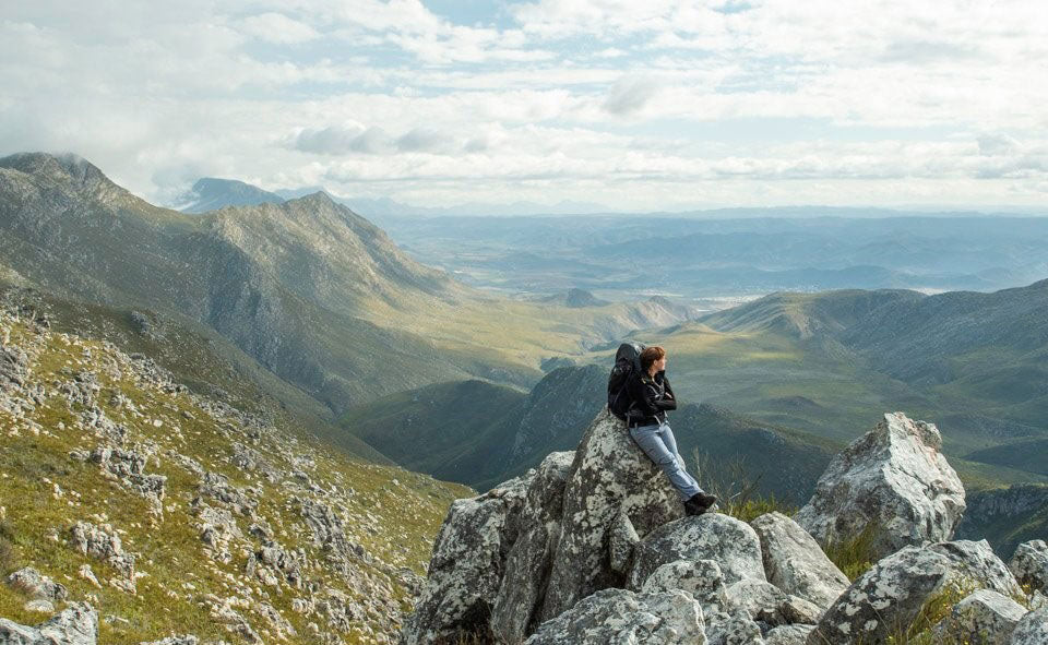
The highest visible peak in this photo is Spitskop – at the same altitude as the overnight huts. Photo by Francis Moult (@francfinds)
Boosmansbos is unique in that it’s a designated Wilderness Area (like Cederberg, Groot Winterhoek, and the Drakensberg). As Mike Lundy writes in Weekend Trails in the Western Cape, a wilderness is “an undeveloped area, uninhabited by man. It should retain an intrinsically wild appearance and give visitors a feeling of isolation from the outside world.” Few trails in the Western Cape share this status. In a Wilderness Area, hikers may sleep wherever they wish — in a cave, bivvy bag under the stars, or tent.

Photo by Francis Moult (@francfinds)
In August 2018, a group of six of us tackled the two-day overnight hike, staying at the Helderfontein Huts. There’s also an option to extend to three days, spending the second night at a recommended campsite.
The paths are well-graded and scenic, winding through ridges and spurs covered in blooming fynbos after winter rains.

Photo by Francis Moult (@francfinds)
After several hours, the trail reaches a high point with views towards Barrydale and dramatic mountain formations of crags and folds.

Barrydale looks just out of sight. Photo by Francis Moult (@francfinds)
Eventually, the path reaches the huts — rustic stone shelters in a valley beside a stream. They’re basic, so hikers need to bring their own sleeping mats and gear — true wilderness style.

Photo by Francis Moult (@francfinds)
From the huts, hikers can descend into a deep river gorge to explore the pocket of indigenous forest known as Boosmansbos. Said to be one of the most pristine forests in the Western Cape, it features towering cypress, stinkwood, yellowwood, candlewood and alder trees. Overgrown paths prevented us from reaching it, but it remains top of our list for a return visit.

Looking down into the cavernous Boosmansbos gorge. Photo by Francis Moult (@francfinds)
Day 2 follows an old forestry jeep track descending the mountain with breathtaking views of folded rock formations. Midway, the route crosses a river valley where hikers can cool off in clear mountain pools. Several tributaries feed into the Duiwenhoks River, offering endless opportunities for exploration.

Descending into the river gorge. Photo by Francis Moult (@francfinds)
The hike ends with the usual mix of exhaustion and awe. Boosmansbos leaves a lasting impression — a wild, untamed landscape that calls you back. Beyond the main route, the adjoining Grootvadersbosch Nature Reserve offers shorter day trails well worth exploring.

Photo by Francis Moult (@francfinds)
In summary, Boosmansbos stands among the Western Cape’s most extraordinary hiking destinations. Between its rolling fynbos slopes, deep forests, and rugged peaks (up to 1600 m), it rivals even the Cederberg and Tsitsikamma for natural splendour and sense of wilderness.
Contact and Booking Info
Reserve: Tel: +27 (0)28 722 2412
Accommodation and permits:
Tel: +27 (0)21 483 0190 / +27 (0)21 659 3500
Email: reservation.alert@capenature.co.za
Website: https://www.capenature.co.za/reserves/boosmansbos-wilderness-area/

Source: CapeNature; Mike Lundy, Weekend Trails in the Western Cape (7th edition), Tafelberg Publishers.