Central Cederberg Circuit
The Cederberg is an open wilderness area with a network of trails where one can wander at will in a wondrous landscape. This route explores some of the most iconic places in the Cederberg and is one of the best 5-day hikes I have done anywhere. It takes you past Crystal Pools, Welbedacht Cave, the Wolfberg Arch and Wolfberg Cracks, the Maltese Cross and Sneeuberg. It can take anything from 4 to 7 days, depending on how many of the side trips one undertakes. The standard 5-day route is a 72km circuit and can be done as suggested here or in reverse. One can also do shorter variations, incorporating sections of this route.
Beauty: 5/5
Difficulty: 7/10 (excluding side trips)
Technical rating: Standard trail walking interspersed with rocky sections and some steep ascents/descents. During rainy season there will be some small stream crossings.
Distance: 72km/78km
 Views from Sleeppad Hut.
What You Need
Please read our article Introduction to hiking in the Cederberg for more information regarding route planning, navigation, the equipment needed and permits/bookings. You will have to be fully self-sufficient and carry tents for shelter.
It is essential to have the Slingsby Hike the Cederberg maps and be able to navigate with it. All trail references and distances shown here are taken from the maps.
 Big Boulder campsite near Crystal Pools.
Start of the Route: Algeria Campsite
The hike starts at the Algeria campsite, on the banks of the Uitkyk River. The drive takes approximately 2.5 to 3 hours from Cape Town via the N7 and incorporates about 18km of dirt road, the conditions of which will vary during the year. Generally it will be fine to drive with a normal vehicle.
The campsite and cottages are managed by Cape Nature and bookings can be made here: Cederberg Wilderness Area.
 Crossing the stream at Algeria the day after a major winter storm.
Algeria to Crystal Pools
(12.8km; 7 hours)
From the Algeria campsite, cross the footbridge and head northeast up the mountain on the clear trail to the right of Helsekloof. The trail zigzags up the steep mountainside to keep the incline manageable, but the 650m vertical gain to Middelberg Hut is a stiff start to the hike. Keep an eye out for the many small cedar trees planted near the top of the kloof.
After crossing into Middelberg Vlakte, the trail turns right past Middelberg Hut at 3.8km. There is a clear pool under some oak trees nearby where one can fill up water bottles.


Enjoy the classic Cederberg scenery of rocky outcrops, sculpted boulders and groves of cedar trees as you walk past Pyramid Peak and Middelberg Central, finally taking the gap between Jurie-se-Berg and Grootlandskop.


 Eenboomkamp (“Lone Tree Camp”) on the Grootlandsvlakte.
The trail continues to the Wildehoutdrif River, where it turns left along the steep banks of Bo Boskloof. It then climbs Groot Hartseer (“Great Heartache”) before plateauing at Horsey Rock, giving a scenic walk to Crystal Pools (12.8km) and Big Boulder Camp – a magical campsite.

Crystal Pools is often visited, and some groups leave litter or make fires. Please pack out all waste, avoid fires entirely, and bury or carry out toilet paper.
 The magical Crystal Pools campsite at sunset.
Crystal Pools to Welbedacht Cave
(11km; 6 hours)
From Crystal Pools the trail heads uphill past the small Crystal Pool hut, then continues through Engelsmanskloof, a picturesque valley of rock formations and cedars.

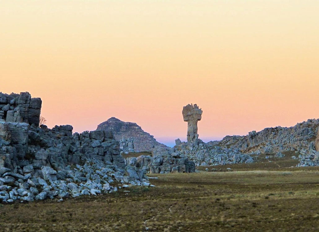
After 5.7km you’ll reach Sleeppad Hut, perched dramatically above a ravine – a highlight stop with panoramic views.
 Sleeppad Hut overlooking the Cederberg valleys.
The route then descends gently to Welbedachtkloof, where you’ll find the impressive Welbedacht Cave – a perfect natural shelter after a rewarding day on the trail.
 The spacious and sheltered Welbedacht Cave.
 Sunset from Welbedacht Cave after a long day’s hike.
Welbedacht Cave to Wolfberg Cracks/Sanddrif Campsite
(14–17.5km; 7 hours)
From Welbedacht Cave, the trail climbs Gabriel’s Pass before reaching the Wolfberg Arch – one of the Cederberg’s most iconic formations. Continue to the Wolfberg Cracks for incredible scenery and optional camping beneath towering cliffs.
 The magnificent Wolfberg Arch.
 The wonderworld of sheer walls and blocky towers in the Wolfberg Main Crack.
Wolfberg Cracks to Sneeuberg Hut
(19.8km; 9 hours)
This long day traverses the Valley of the Red Gods, Sanddrif Campsite, the Maltese Cross, and ends at Sneeuberg Hut. Expect changing landscapes, from vineyards to dramatic sandstone formations.
 The striking Maltese Cross, a Cederberg landmark.
 Sneeuberg glowing with the day’s first light.
Sneeuwberg Hut to Uitkyk Pass/Algeria
(14–20km; 7 hours)
The final stretch leads past Frikkie-se-vlakte, Koerasieberg, and Duiwelsgatkloof before finishing at Uitkyk Pass. Many hikers end here and fetch cars from Algeria – a fitting close to a world-class circuit.
 Final descent to Uitkyk Pass – the perfect end to the Cederberg Circuit.
Side Trips
- Tafelberg and Spout Cave – from Welbedacht Cave (7km round trip; +1 day)
- Wolfberg Narrow Crack (+2 to 3 hours)
- Sneeuberg Peak – from Sneeuberg Hut (10.5km round trip; +1 day)
For more details, see Four Amazing Cederberg Peaks.
Bookings and Permits
Contact Cape Nature at +27 21 483 0190