Tsitsikamma Trail
The Tsitsikamma Trail is the third jewel in the crown of multi-day hiking routes along the Garden Route. It’s a great alternative if the Otter Trail or Outeniqua Trail is fully booked.
Beauty: 3.5/5 – Large sections of plantation roads are interspersed with stunning indigenous forests and mountain views.
Difficulty: 6/10 – Relatively long days that require moderate to good fitness.
Technical rating: Standard trail walking with occasional small river crossings and some beach walking on Day 1.
Day 1: Nature’s Valley to Kalander (3.6 km)
The trail begins at De Vasselot Caravan Park in Nature’s Valley. It’s a straightforward hike to Kalander Hut, about 3.5 km away across the beach. Look for the forested entrance to the hut along the eastern edge of the lagoon.
Because Day 1 is short, arrive early to enjoy the beach in the afternoon — swim, play beach bats, or relax beside the lagoon.

The trail to Kalander Hut begins along the beach at Nature’s Valley.

Kalander Hut is perfectly positioned for late afternoon swims and beach relaxation.
*De Vasselot is also the endpoint of the Otter Trail, so Day 1 may feel like a nostalgic retrace of your final Otter steps.
Day 2: Kalander to Bloukrantz (16.6 km)
Day 2 begins with a steep climb to the plateau overlooking Grootkloofbos — the longest day of the trail. Take it slow and enjoy the changing views as you ascend. Once on the plateau, the path meanders through thick forest alive with birdsong and the rustle of the wind in the trees.

Grootkloofbos seen from the top of the plateau, wrapped in early morning mist.
Stop for a refreshing swim at the waterfall about 10 km in before entering the final section through pine plantations. Most hikers’ GPS devices log this day closer to 18 km.

The sun-dappled Blackwood Path on the plateau.

The pool and waterfall at 10 km provide the perfect spot for a break.
Bloukrantz Hut is one of the most scenic overnight stops on the trail, with panoramic mountain views and a series of coppery rock pools in the Tolbos River below — ideal for soaking tired legs after a long day’s walk.

The panoramic view from the Bloukrantz Hut stoep.
Day 3: Bloukrantz to Keurbos (13.4 km)
This day winds through lush indigenous forests filled with ferns, lichen and moss. The Bloukrantz River crossing — supported by a safety rope — is a highlight, though after heavy rain it may not be passable. Watch your footing on slippery rocks.

Fairytale-like indigenous forest typical of the Tsitsikamma Trail.
Most of the day’s walking is gentle, through forest thickets and occasional fynbos patches. Look out for yellowwoods, Cape chestnuts and colourful fungi decorating ancient boulders.
Day 4: Keurbos to Heuningbos (13 km)
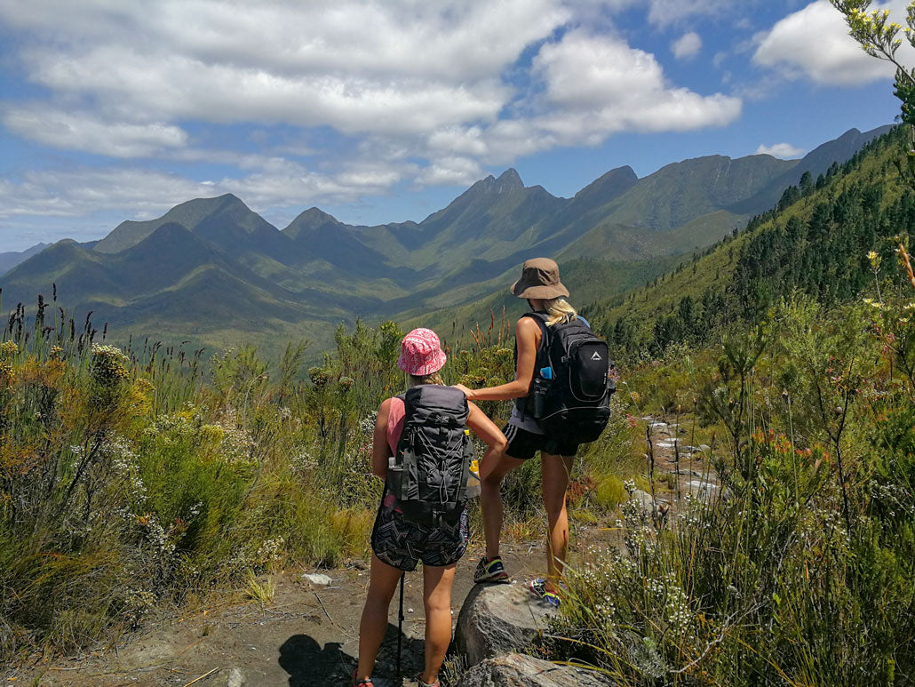
Day 4 delivers some of the most striking mountain scenery. From Rushes Pass — between Klipbokkop and Elandskop — you’ll look back over the Lottering Valley, framed by encircling peaks. Later, the route passes through lush forest along Heuningkloof, ending at Heuningbos Hut with deep pools nearby for swimming.

The view from Rushes Pass, looking back toward Keurbos Hut.
Day 5: Heuningbos to Sleepkloof (14 km)
The trail climbs steadily up Splendid Pass and Mostertshoogte, then descends to cross the Witteklip River before the final climb to Nademaalsnek. These steep ascents and descents make it one of the tougher sections. The forest near Sleepkloof Hut is dense and cool — a final taste of Tsitsikamma’s magic.

The final section through forest offers refreshing mountain pools for a last dip.
General Tips
- Best hiked between October and April for warmer, safer river crossings.
- Coordinate logistics ahead of time, especially for slackpacking groups.
- Start early each day — it allows time to manage issues or enjoy the huts in daylight.
- After heavy rain, river crossings can be dangerous. When in doubt, wait or turn back.
- Carry essentials: rain gear, headlamp, snacks, water, warm clothing and first aid.
- Familiarize yourself with updated route and safety information before starting the trail.
Bookings
MTO Forestry (Pty) Ltd
Phone: 087 158 2110
Email: info@mtoecotourism.co.za